Geoscience Division
Mission
- To develop and sustainably manage the mineral resource, coastline and marine environment of Kiribati to safeguard the livelihood of the people of Kiribati and to maximize and foster broad-based growth of our economic resources.
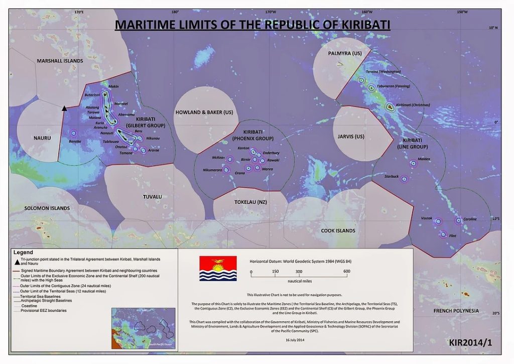
Maritime Boundaries
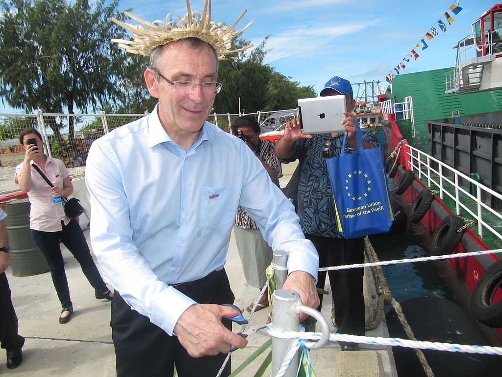
Kiribati declared its EEZ in 1978; it was therefore known that the huge area of ocean had great potential for development of tuna industries and other marine resources. Currently, the Maritime Boundary or Exclusive Economic Zone was fully established for the Gilbert Island Group, Line Island Group and the Phoenix Island Group in 2010 by the Ministry of Fisheries and Marine Resources Development. With the aasistance from SOPAC, Commonwealth Secretariat, Australian AG’s office and UNEP, the two Ministries were able to establish the correct and precise maritime boundary of the three Island Groups. The joint effort takes 4 years to complete and on the 31st of December 2014 three maritime boundaries were correctly mapped and positioned. The Exclusive Economic Zone 200nm (370.4km size), Contiguous Zone 24nm (44.4km size) and the Territorial Sea 12nm (22.3km size) are now recognized under the UN convention on the Law of the Sea. These maritime boundaries designates Kiribati jurisdiction over its waters.
Deep Sea Minerals
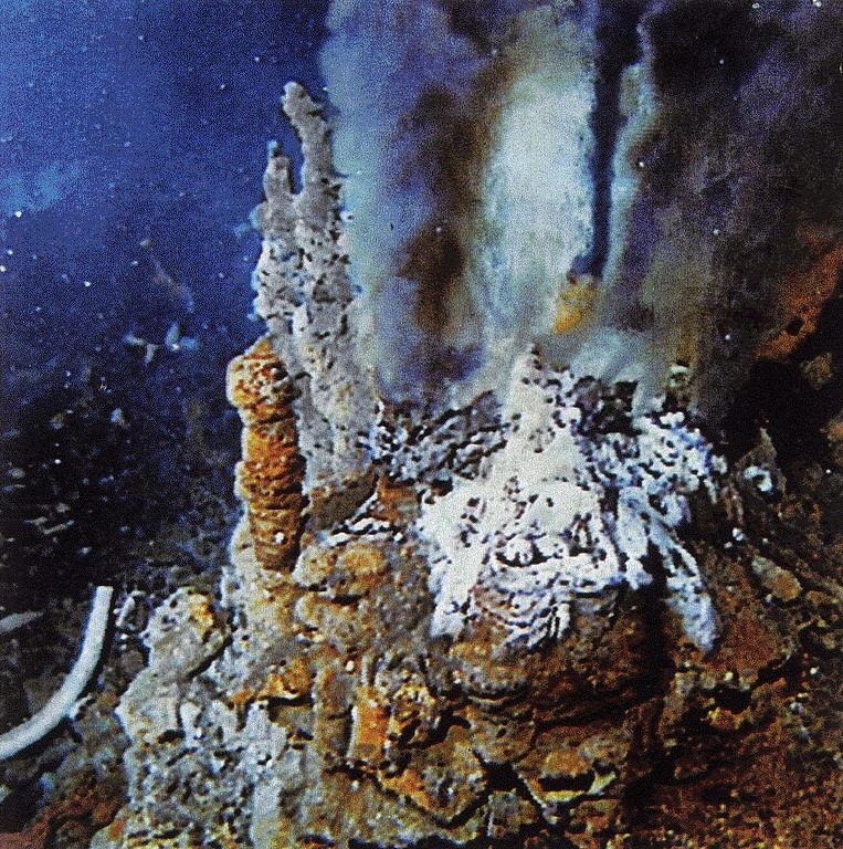
Kiribati has a vast Exclusive Economic Zone (EEZ), one of the biggest in the region. It has three separate and distinct island groups, each with its own separate EEZ: the GIlbert Island Group, the Phoenix Island Group and the Line Island Group. Early marine minerals exploration in Kiribati waters was undertaken as part of the Pacific Ocean expendition in the 1960s and early 1970s. The first reported survey in the Kiribati area was during the 1979 CCOP/SOPAC investigations for potential manganese nodules and crust nodules and crust, precious coral and phosphate. Investigations for cobalt rich crust and metalliferous sediments were not carried out in Kiribati until 1987 during the ‘RV Moana Wave’ and ‘RV Hakurei Maru 2’ exploratory cruises in the region. These early prospecting efforts within the EEZ of Kiribati were aimed at identifying mineral occurrences particularly manganese nodules and cobalt rich crust resources. A major part of this was three Japan-SOPAC Cooporative Study research cruises that were carried out in Kiribati in 1887, 1989, and 1991. These later surveys were a significant milestone as they confirmed the mineral resources potential within Kiribati EEZ.
Geological Survey
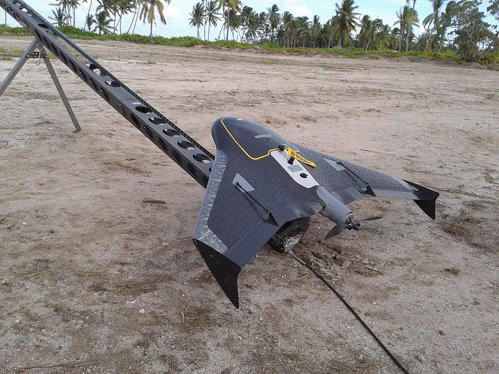
A geological survey is the systematic investigation of the geology beneath a given piece of ground for the purpose of creating a geological map or model. Geological surveying employs techniques from the traditional walk-over survey, studying outcrops and landforms, to intrusive methods, such as hand auguring EEZ. and machine-driven boreholes, to the use of geophysical techniques and remote sensing methods, such as aerial photography and satellite imagery. Such surveys may be undertaken by state, province, or national geological survey organisations to maintain the geological inventory and advance the knowledge of geosciences for the benefit of the nation. The Ministry of Fisheries also employs some of the methods of geological survey including satallite images and aerial photography. These methods involves the use of GIS softwares like QGIS, ArcGIS and MapInfo in order to sketch the bethymetry and the sea depth of each Islands.
Marine Spatial Planning
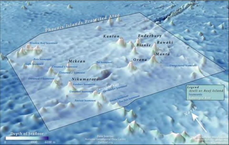
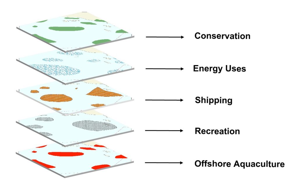
Marine spatial planning (MSP) is a process that brings together multiple users of the ocean – including energy, industry, government, conservation and recreation- to make informed and coordinated decisions about how to use marine resources sustainably. MSP generally uses maps to create a more comprehensive picture of a marine area – identifying where and how an ocean area is being used and what natural resources and habitat exist. It is similar to land-use planning, but for marine waters. For instance, the closing and protection of Phoenix Islands for marine protected area. Though the planning and mapping process of a marine ecosystem, planners can consider the cumulative effect of maritime industries on our seas, seek to make industries more sustainable and proactively minimize conflicts between industries seeking to utilized, but within clear environmental limits to ensure marine ecosystem remain healthy and biodiversity is conserved.
Inshore Activity
Coastal Monitoring & Management
Coastal Monitoring Programme aims to provide a standard, repeatable and cost-effective method of monitoring the coastal environment. This program involves GPS survey, coastal assessment, management of coastal mining and monitoring on coastal development. The increasing pressure and destruction of the coastline in most areas around Kiribati have increased the Ministry effort towards coastal monitoring and management. As part of this program, The Ministry of Fisheries and Marine Resources Development and the Ministry of Environment, Lands and Agriculture Development work in collaboration with other regional and international bodies to effectively monitor and predict the beach alteration and manage most of the coastal development and activities. Some of these serious activities involve coastal mining and seawall development have become a serious issue in terms of coastal erosion and degredation. Te Atinimarawa is one of the government owned sand and gravel mining company that is now suppling the demands for sand and gravel on South Tarawa to reduce the pressure from unsustainable mining carried out by most people on South Tarawa.
Geographical Information System (GIS)
A geographic information system (GIS) lets us visualize, question, analyze, and interpret data to understand relationships, patterns, and trends. GIS benefits organisations of all sizes and in almost every industry. The Ministry of Fisheries and Marine Resources Development also has its own GIS division that falls under the Mineral Unit. GIS is used by the Mineral division as a tool for initiating changes to the coastline caused from climate change, human activities and other factors occurs from time to time. Through GIS, we also manage to make data on the bathymetry, elevation and maps for most Islands around Kiribati. This important data and information can be used by the government to plan for future development projects.
Sandwatch
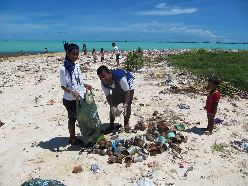
Sandwatch is a program in which children, youth, schools and adults work together to scientifically monitor and critically evaluate the problems facing the beach environments. This acitivity assist in designing and implementing practical activities and project to address particular issues, enhance beach environment and build resilience to climate change. The Ministry of Fisheries and Marine Resources Development started the sandwatch program in 2012 involving student from all senior secondary schools on South Tarawa. This program includes clean up campaigns along the beaches of South Tarawa. Sandwatch also adopts a combined approach to climate change adaption and education for sustainable development, in order to provide a tool for children, youth, teachers, NGOs, and communities to integrate knowledge and activities relating to climate change into the Sandwatch programme
Awareness
School Visit
We conducted school visit programs on different topic involving offshore and inshore activities. One of the latest school visits was done last year on Deep Sea Mining (DSM). The purpose of school visit programs is to develop and enhance the knowledge and understanding of each student in Kiribati on the geological, technological, biological, environmental and legal aspect of deep-sea mining. Senior secondary schools around Kiribati are targeted for these programs in order to provide them with the basic idea on the social-economic benefits of DMS to the country and to their future career.
Radio Program
One of our major activities involves announcement on awareness programs and other important activities carried out by the Ministry (Mineral Division) throughout the year. New research and studies concerning the potentials of our marine resources are being announced for public notice. Research and study like the extraction of Deep Sea Minerals is one of our major activities that is still being broadcasted through the AM channel. The broadcasting included in the radio news updates and question and answer programs or usually known as TE NIMAU AKEA.
Consultation
The aim for consultation is to understand stakeholders’ views on range of new development undertaken by the Ministry in order to formulate inclusive actions and policies that will benefits the country as whole. Consultation is a two-way process of dialogue between the Ministry and its stakeholders. Stakeholder’s consultation is really about initiating and sustaining constructive external relationships over time. Most projects that are to be developed by the Ministry require views and opinions from stakeholders before being launched. Due to the fact that there could be environmental and social impact of these projects that can affect the